|
previous topic :: next topic |
| Author |
Message |
apctjb
Since 19 Aug 2007
440 Posts
Obsessed
|
 Mon Sep 01, 08 2:27 pm New sandbar-kite launch on the WA side across from HR? Mon Sep 01, 08 2:27 pm New sandbar-kite launch on the WA side across from HR? |
 |
|
Anyone have information on the date for the removal of the existing dam from the White Salmon river (it was scheduled for this year)? When the dam goes there is 100years of sediment behind the dam that I assume is going to wash downstream into the Columbia.
Could that sediment be put to good use to creat a sandbar on WA side at the mouth of the White Salmon? Any ideas on what it would take to stabilize the bar so it does not wash away (the river flows fast along the WA shore at the mouth of the White Salmon). Who would be the right person to contact to lobby for the idea? Note there is access under the White Salmon RR bridge so the RR crossing issues occuring at Lyle, where there is no easy way under the RR tracks could easily be avoided at the White Salmon.
|
|
|
pdxmonkeyboy

Since 16 May 2006
6081 Posts
forever labled as the
retired kiter & motorhead Unicorn Master
|
| Mon Sep 01, 08 3:14 pm |
|
|
you would start by contacting the landowner of the parcel where you want this beach. One buzz kill though.. the sediment you speak of is likely going to consist of very fine grain particles that have settled out of solution because of the low velocity of water behind the dam. That sediment would not make a good substrate to create a beach in the Columbia. You need rock, structural soil, and probably some sand to do that.
Rock being the key ingredient.
Bottom line, its hard to create a sand/gravel bar in a river (especially one as large and powerful as the Columbia) where one doesn't occur naturally....
|
|
|
jblum
Since 13 Jul 2008
308 Posts
The Gorge
Obsessed
|
| Mon Sep 01, 08 5:18 pm |
|
|
I partly agree, but mostly disagree here.
The dam is likely to be removed in the next year or two. They are processing a few final removal docs and need final removal order from FERC and then its gone.
As far as what's behind it that will be coming downstream: The dam has blocked everything from going downstream for the past 100 years. They are going to use a dam removal technique called "blow and go", blasting a 10x20ft hole in the bottom, draining the whole thing in 4-6 hours. They are doing it this way in order to remove as much sediment as possible in the first few hours. They estimate it will take 75% down with it.
That much stuff coming downstream will make an impact on the Columbia, and will probably result in some sort of sandbar.... It will mimic a catastrophic event (such as a volcanic eruption, landslide, or creek blowout) and will result in some sort of deposition. Take a look at the change in the sandbar from the Hood River (I think it grew more than 10 acres) the other winter in the high water flooding. We will see something new, its just a question of what...
_________________
JHB |
|
|
Spike

Since 13 May 2007
1414 Posts
Alameda
Spelling Expert
|
| Mon Sep 01, 08 5:48 pm |
|
|
| Anybody have any idea if "blowing a hole in the bottom" is going to be a public event? I would sure like to see that!
|
|
|
pdxmonkeyboy
Since 16 May 2006
6081 Posts
forever labled as the
retired kiter & motorhead Unicorn Master
|
| Mon Sep 01, 08 6:48 pm |
|
|
| jblum wrote: | I partly agree, but mostly disagree here.
|
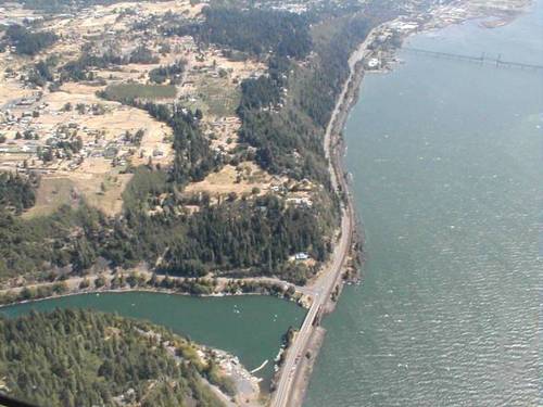
We could put $20 on it if you want. The white salmon empties into the columbia on the outside bend of the channel meander. This is the deepest and fastest flowing part of the river. Suspended sediment load means nothing if the sediment does not have a place to settle out of suspension. If you look at aerial photos of the cpulmbia you'll see what i'm talking about. There is either a natural land mass that causes a backwater (Lyle) or sand bars are on the inside bend of channel meanders..HR.
If anything, you can look to see wells island grow a little bit but I'll put cold hard cash down that the damn removal will not form a sand bar at the mouth.
|
|
|
pkh

Since 27 Feb 2005
6549 Posts
Couve / Hood
Honored Founder
|
| Mon Sep 01, 08 9:37 pm |
|
|
PDXMB - How about instead of a bet you vow to never kite there if it does form a sandbar? 
|
|
|
pdxmonkeyboy
Since 16 May 2006
6081 Posts
forever labled as the
retired kiter & motorhead Unicorn Master
|
| Tue Sep 02, 08 12:04 am |
|
|
in the words of mr. Garrison, there is no such thing as a stupid question.
Just stupid people.
But what the he'll, if a sand bar forms, and it's large enough to kite from and their is public access I promise not to kite there.
Bug if it doesn't form; you can make me moderator for a day.

|
|
|
pkh
Since 27 Feb 2005
6549 Posts
Couve / Hood
Honored Founder
|
| Tue Sep 02, 08 5:53 am |
|
|
| haha, okay but we have to be really sure its not going to form... got to wait like 10 years.
|
|
|
moondog
Since 15 Aug 2007
706 Posts
white salmon
Addicted
CGKA Member
|
| Tue Sep 02, 08 7:14 am |
|
|
The new washington sandbar event is planned for fall of 2009. I can hardly wait for the big show, but I would be surprised to see anything form there because of the depth of the water.
_________________
moondog |
|
|
wylieflyote

Since 30 Jun 2006
1648 Posts
Puget Sound & Wa. Coast
XTreme Poster
|
| Tue Sep 02, 08 7:55 am |
|
|
My guess is that it might only fill up somebody's favorite fishing hole:
 |
| |
4408643.jpg |
_________________
CGKA Member
-------
Kip Wylie |
|
|
tinyE

Since 21 Jan 2006
2004 Posts
not really an
XTreme Poster
|
| Tue Sep 02, 08 8:10 am |
|
|
| or...Home Valley doubles in acreage !
|
|
|
Jackal
Since 17 Dec 2005
147 Posts
WS
Stoked
|
| Tue Sep 02, 08 9:23 am |
|
|
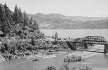
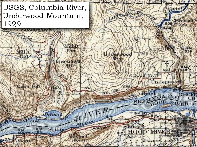
As much as I hope a new sand bar forms- it's definitely a long shot. Lewis and Clark called the WS Canoe creek, but made no mention of a sandbar. Maybe some silt will accumulate on the banks just west of the bridge for a small beach.
I can't find any picts from before the damn- which was 1913, here's some from later with sand bars before the confluence, which don't appear very much anymore. The USGS map from 1929 shows the HR sand bar.
Looking forward to it with or without a sandbar-
Free the White Salmon!
 |
| |
library-congress-archives_white_salmon_Rothstein_1936_mini.jpg |
 |
| |
map_usgs_topo_underwood_mountain_1929.jpg |
|
|
|
Spike
Since 13 May 2007
1414 Posts
Alameda
Spelling Expert
|
| Tue Sep 02, 08 9:56 am |
|
|
Yay! more dirty coal power in the place of hydro, cheer on the progress 
|
|
|
pdxmonkeyboy
Since 16 May 2006
6081 Posts
forever labled as the
retired kiter & motorhead Unicorn Master
|
| Tue Sep 02, 08 9:59 am |
|
|
Don't get me wrong, I couldn't be more stoked about removing the dam. Their is a metric shit load of sediment and debris behind it.. 2.4 million cubic yards. Thats ALLOT of dump trucks folks. I red through some of the EIS (environmental impact statements) that ecology recently completed. They are expected up to 5-feet of sediment to accumulate downstream of the WS river although the sediment transport modeling is supposedly a little shaky. 5-feet of sediment would barely be visible along the shoreline near the WS bridge.
Much of the sediment will deposit in the Bonneville pool area (Stevenson) although they are expecting sediment to accumulate in the Indian fishing grounds at the mouth of the white salmon. The natives will have around 1/2 million bucks for restoration of this area and will likely dredge out sediment accumulations.
Anyways, it is a super cool project for sure. It is going to be pretty fascinating watching the river re-establish itself after the damn is removed.
|
|
|
forrest

Since 21 Jun 2005
4330 Posts
Hood River
Hick
CGKA Member
|
| Tue Sep 02, 08 10:11 am |
|
|
| Katie and I just hiked the entire pipe the other day, super cool hike! Can't wait to see this thing blow up!
|
|
|
kitezilla

Since 22 Jun 2006
453 Posts
gorge
Obsessed
|
| Tue Sep 02, 08 10:46 am |
|
|
Is anybody guessing that a lot of the sediment will eddy out in the 2 largest eddys between the Hatchery buildings and the "Hatch", or fill in Canadian Cove, or fill in the eddy betweens the Finks point and Swell City....Just imagine launching on sand at the Hatch!...Windsurfers to the West and nothing but Kiter Waves to the Eastern horizon.
We can only dream...but keep in mind that the Gorge is renown for cataclysmic changes...if the eddys fill up with sand, it will probably happen in something like 48 hours.
We can line up and post a watch at the Hatchery, like the Indians did at Celilo Falls, when The Dalles dam went in and within a matter of hours backed up the dam pool, flooding the falls. We, like the Indians will watch with tears in our eyes, only ours will be tears of joy.
Fall of 2009, you say...just a little over a year away!
|
|
|
4Stringer/KipWinger

Since 27 Apr 2005
541 Posts
Hood River
Addicted
|
| Tue Sep 02, 08 10:49 am swell effect |
|
|
Probably the more practical question is;
how is the sediment going to effect the swell ? I doubt any of us have any immediate answer, but will conduct plenty of on-water research to find out the effect once the dam's gone.
|
|
|
|