|
previous topic :: next topic |
| Author |
Message |
kyle.vh
Since 11 Jul 2007
713 Posts
city of angels
Addicted
|
 Thu Apr 02, 09 8:09 pm This weekend. Thu Apr 02, 09 8:09 pm This weekend. |
 |
|
Easterlies and warm & sunny.
I feel like we haven't had a good RR session in awhile. Could be mid-60s.

Also: if you haven't checked out windonthewater.com/wotw and set it up to text/call you with real time data, check it out, its really cool. and free.
|
|
|
stringer

Since 31 Jul 2007
694 Posts
Chucktown
Flying Tomato
|
| Thu Apr 02, 09 9:39 pm |
|
|
Looks like fun!
Would like to winch at least if the wind/water doesn't cooperate.
At the mouth of the Washougal river the water looked pretty high. None of those rocky parts were exposed.
It might be a bit lower at rooster since its not a rivermouth.
_________________
http://www.flickr.com/photos/10069384@N05/sets/ |
|
|
hilton
Since 15 Aug 2008
816 Posts
Opinionated
|
| Fri Apr 03, 09 5:56 am Sunday looks great! |
|
|
Sunny, Warm, and Windy (but not nuked out) on Sunday.
WESTERN COLUMBIA RIVER GORGE-
.SUNDAY...MOSTLY SUNNY. BREEZY...WARMER. HIGHS 65 TO 70. EAST WIND 15 TO 25 MPH CASCADE LOCKS WESTWARD.
|
|
|
Moto

Since 03 Sep 2006
2698 Posts
Still a gojo pimp!
Moto Mouth
|
| Fri Apr 03, 09 7:49 am |
|
|
Anyone seen the water levels at RR? If its easterly winds this weekend would be sweet to get a sesh in at Rooster.
_________________
Still rockin gojos, *ssless chaps, and ankle weights! |
|
|
tinyE

Since 21 Jan 2006
2004 Posts
not really an
XTreme Poster
|
| Fri Apr 03, 09 7:55 am |
|
|
| Moto wrote: | | Anyone seen the water levels at RR? If its easterly winds this weekend would be sweet to get a sesh in at Rooster. |
only a few more donations, and we can all see all the time! 
|
|
|
Nak

Since 19 May 2005
4334 Posts
Camas
Site Lackey
CGKA Member
|
| Fri Apr 03, 09 8:01 am |
|
|
| Water looks pretty high here in Camas...
|
|
|
kyle.vh
Since 11 Jul 2007
713 Posts
city of angels
Addicted
|
| Fri Apr 03, 09 2:39 pm |
|
|
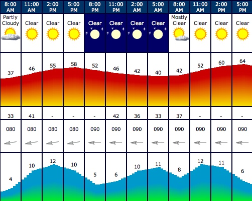
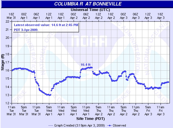
i'm hoping for some beach, but launching in the water isn't bad unless it's super high. especially if there's a few people there.
does anyone know how to interpret the graph for beach at RR? chooch, i though you mentioned this once, but i searched and didn't see...
(link for water level is here: http://ahps2.wrh.noaa.gov/ahps2/hydrograph.php?wfo=pqr&gage=bono3&view=1,1,1,1,1,1,1,1&toggles=10,7,8,2,9,15,6&type=0)
looks like it won't even be nuked. could be great riding.
 |
| |
rr_wkend.jpg |
 |
| |
h2olevel.jpg |
|
|
|
FlyDunes

Since 09 Oct 2007
1034 Posts
Aloha
XTreme Poster
|
|
|
stringer
Since 31 Jul 2007
694 Posts
Chucktown
Flying Tomato
|
|
|
FlyDunes
Since 09 Oct 2007
1034 Posts
Aloha
XTreme Poster
|
| Sat Apr 04, 09 8:13 am |
|
|
Nice pics. I'm really surprised that the water is that high! The vancouver hydrograph doesn't usually drop below 2-3 feet even at the lowest point in the season, and it's only reading 4-5 feet now.
_________________
Lets FLY |
|
|
Nak
Since 19 May 2005
4334 Posts
Camas
Site Lackey
CGKA Member
|
| Sat Apr 04, 09 8:47 am |
|
|
http://ahps2.wrh.noaa.gov/ahps2/river.php?wfo=pqr&wfoid=18685&riverid=204540&view=1%2C1%2C1%2C1%2C1%2C1%2C1%2C1&toggles=10%2C7%2C8%2C2%2C9%2C15%2C6&pt[]=141844&pt[]=146323&pt[]=143917&pt[]=144487&pt[]=145817&pt[]=143083&allpoints=141844%2C146323%2C143917%2C144487%2C145817%2C143083%2C142943%2C144837&data[]=hydrograph&submit=Make+my+River+Page!
Water level at the dam changes a lot more than at Vancouver. Right now it's at 15 feet; it goes as low as 5 feet in late Summer/early Fall. The level at the dam doesn't seem to relate 1 to 1 with RR water level. (I don't think RR is 10 feet higher now than late Summer.) But there is definitely more effect at RR than at Vancouver. That makes sense, because by the time you get to Astoria, Dam levels have no effect at all.
I've watched RR levels, and the dam level isn't an exact indicator. 11 ft at the dam doesn't always mean you'll see the same level at RR. Even throwing in the tides isn't an exact indicator. (Although it gives you a good guess.) Dam level and tides both affect current and depth, and there's some kind of dynamic relationship there. Plus, I'm pretty sure ground level at RR beach changes too. When the beach is underwater, sand is deposited there. When the beach is exposed, sand blows away. Sand Island especially goes up and down a lot, 3 or 4 feet I think. I know that seems like a lot, but it sure seems like it does.
I know, Blah, blah, blah. What it boils down to is nothing beats eyeballing it to see what's going on. Thanks Stringer!
|
|
|
|