|
previous topic :: next topic |
| Author |
Message |
undertow

Since 15 Feb 2008
371 Posts
BeaversBurg
Obsessed
|
 Wed Nov 02, 11 10:03 am Wed Nov 02, 11 10:03 am |
 |
|
| On nuked out days a RR, I have gone to Lewis and Clark St Park, just west. Its a hike but always had smooth 10m wind, and nice flatwater.
|
|
|
Nak

Since 19 May 2005
4340 Posts
Camas
Site Lackey
CGKA Member
|
| Wed Nov 02, 11 10:19 am |
|
|
| When you hike in, do you launch on the west or East side of the Sandy? The West side changed dramatically this year, much less beach.
|
|
|
undertow
Since 15 Feb 2008
371 Posts
BeaversBurg
Obsessed
|
| Wed Nov 02, 11 11:31 am |
|
|
| East side, there is a road that leads to the river, or you can walk the trail that parallels 84 and go east then go left and around to the river.
|
|
|
Youkai

Since 08 Feb 2010
553 Posts
Beaverton
Addicted
|
| Wed Nov 02, 11 11:39 am |
|
|
I see two roads. Do you mean the one that goes NE near the "Gary Island Park" or the one that goes more more north by where the Sandy meets the Columbia?
Also are you allowed to drive in? I see what looks like a parking loop on the north side of 84. Is that where the hike starts from?
_________________
Captain kook; always wrong. |
|
|
undertow
Since 15 Feb 2008
371 Posts
BeaversBurg
Obsessed
|
| Wed Nov 02, 11 12:37 pm |
|
|
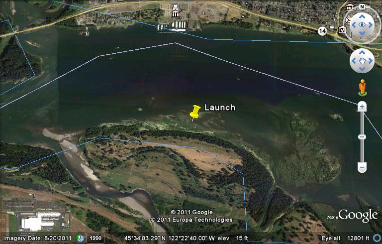
the road by the Sandy is the one, you can try driving it has been gated before. There is parking near that road, via the side of the frontage road, I usually park in the parking lot and hike near the corral and NE, when I get to a water tank I continue NE till I see the river then backtrack west along the river. should be plenty of beach.
If I was more savy, I would post a doctored map from Google Earth.
|
|
|
Youkai
Since 08 Feb 2010
553 Posts
Beaverton
Addicted
|
| Wed Nov 02, 11 1:36 pm |
|
|
If you go to google maps and zoom in on the location then right click on the spot and "Center map here" then the link URL will have the exact GPS coordinates for where you kite from which people can see on google maps by searching for the coordinates.
For instance. Is this where you launch from (The green arrow not the closest address it places the marker at)? 45.566918,-122.383618
_________________
Captain kook; always wrong. |
|
|
undertow
Since 15 Feb 2008
371 Posts
BeaversBurg
Obsessed
|
|
|
undertow
Since 15 Feb 2008
371 Posts
BeaversBurg
Obsessed
|
| Wed Nov 02, 11 2:16 pm |
|
|
| [img]file:///C:/Users/George/Desktop/Sandy%20River%20Park.jpg[/img]
|
|
|
Youkai
Since 08 Feb 2010
553 Posts
Beaverton
Addicted
|
| Wed Nov 02, 11 2:44 pm |
|
|
That image url thing only works with images that are on the web. You need to just attach that image to your post.
_________________
Captain kook; always wrong. |
|
|
Mark

Since 20 Jun 2005
3679 Posts
I need my fix because I'm a
Naishaholic
|
| Wed Nov 02, 11 3:25 pm |
|
|
Where was everyone? Three of us had a great sess. Noon to three.
_________________
Cleverly disguised as an adult...
www.naishkites.com |
|
|
Youkai
Since 08 Feb 2010
553 Posts
Beaverton
Addicted
|
| Wed Nov 02, 11 3:42 pm |
|
|
I was there too early. Wind was crazy. What size were you flying?
_________________
Captain kook; always wrong. |
|
|
Mark
Since 20 Jun 2005
3679 Posts
I need my fix because I'm a
Naishaholic
|
| Wed Nov 02, 11 3:45 pm |
|
|
2012 6M Naish Bolt. Sucked up the high wind nicely.
_________________
Cleverly disguised as an adult...
www.naishkites.com |
|
|
Wind Slither

Since 04 Mar 2005
2650 Posts
The 503
METAL
|
| Wed Nov 02, 11 4:15 pm |
|
|
| Mark wrote: | | Where was everyone? Three of us had a great sess. Noon to three. |
We saw you guys coming down as we were hopping off...seem to be dropping off as I drove out.
Highly strung on 6M's till 2 out front at RR.....November river session in the bag! 
|
|
|
KP
Since 05 Apr 2011
23 Posts
|
| Wed Nov 02, 11 5:30 pm Nukin Rooster |
|
|
Kited Marine Drive at about 148th ave.
Gusty but hey this is the Columbia, sweeet til a line broke on the beach at gov't Island.
Retied it and kited back
good spot for nukin easterlies.
Many more sessions left this year!!
|
|
|
stringy

Since 23 Jun 2006
1742 Posts
vancouver
XTreme Poster
|
| Wed Nov 02, 11 7:20 pm |
|
|
is lewis and clark park different than oxbow?
I always hit oxbow with the dogs when I'm down in PDX.
today looked pretty intense according to ikite.
mark barnes on a 6m sounds pretty windy.
_________________
www.jimstringfellow.com |
|
|
undertow
Since 15 Feb 2008
371 Posts
BeaversBurg
Obsessed
|
| Thu Nov 03, 11 6:35 am |
|
|
Lewis and Clark St. Park is more at the mouth of the Sandy and along the Columbia.
 |
| |
Sandy River Park.jpg |
|
|
|
|