|
previous topic :: next topic |
| Author |
Message |
moondog
Since 15 Aug 2007
706 Posts
white salmon
Addicted
CGKA Member
|
 Sun Jul 17, 11 8:05 am White Salmon River sand bar Sun Jul 17, 11 8:05 am White Salmon River sand bar |
 |
|
Took a boat with a depth finder over to the White Salmon bridge yesterday. The depth between the 2 white buoys and the bridge is 24-31 feet. That diminishes our chances of seeing a sandbar there when the Condit Dam blows in October. You can reference my post May 26 at 12:56 to see the White Salmon sandbar before Bonneville Dam was built!
_________________
moondog |
|
|
moondog
Since 15 Aug 2007
706 Posts
white salmon
Addicted
CGKA Member
|
| Sun Jul 17, 11 8:13 am |
|
|
The best reference photo is the first one by "wakeup" on page 1
_________________
moondog |
|
|
kitezilla

Since 22 Jun 2006
453 Posts
gorge
Obsessed
|
| Mon Sep 12, 11 9:00 am |
|
|
Here's the latest on the Condit Dam removal....might be fun to volunteer for the "derelict" boat clean up.
I keep hoping that the sediment will end up in the coves at the Hatch...sandy beach kite launch...
http://www.cbbulletin.com/412242.aspx
|
|
|
moondog
Since 15 Aug 2007
706 Posts
white salmon
Addicted
CGKA Member
|
| Tue Sep 13, 11 7:21 am |
|
|
Underwood eddy is what's up it is shallower there than the channel
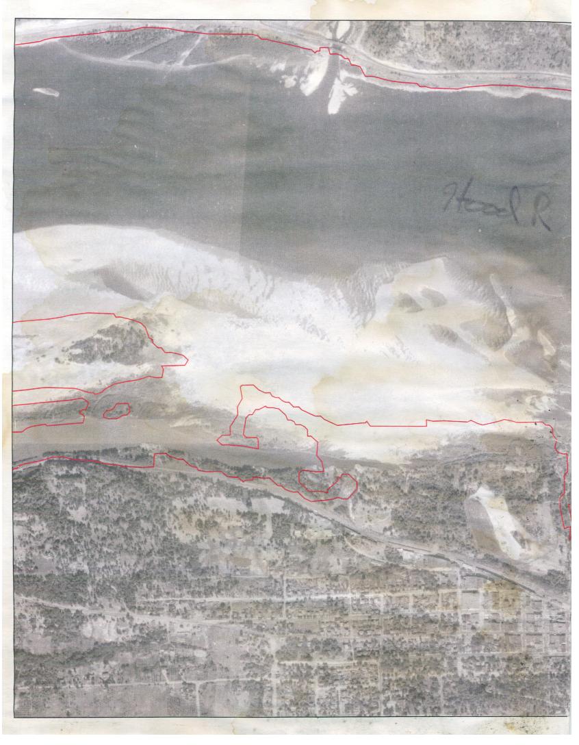
My buddy works for the USGS and gave me this pic years ago. The shot was taken in 1935 before the dams went in on the Columbia. The redline represents the shoreline as it was in 2002-3.
While your checkin out the massive sandbar at the mouth of the WS, look at what the sandbar may look like in another 500-10000 years. Mother nature is doing her thing.
Sandbar.jpg
Description:
Download
Filename: Sandbar.jpg
Filesize: 129.92 KB
Downloaded: 214 Time(s)
Note: Use Pixlr to resize images to lower than 1024x768 resolution so they show up inline.
 |
| nice reference picture! |
Sandbar.jpg |
_________________
moondog |
|
|
pdxmonkeyboy

Since 16 May 2006
6081 Posts
forever labled as the
retired kiter & motorhead Unicorn Master
|
| Tue Sep 13, 11 10:31 am |
|
|
moondog, that is a sweet picture!!
One thing that you guys and gals need to remember however is, as moondog had said, that picture was taken prior to construction of dams on the Columbia river. One of the most deleterious effects of dams (the list can be long) is that they disrupt the flow of sediment downstream. On a very simple level, all streams do is take pieces of earth from point A and transport it downsteam to point B. When combined with complex hydrology, hydraulics, and geology, this process results in complex stream channels, sand bars, flood plains, and complex instream and riparian habitats.
The condition now however is that all the sediment that once flowed down the river and formed those immense sand bars is no locked behind the dams. That is ALLOT of sediment..like a metric fuckload. There is approximately 2 MILLION TONS of sediment behind condit dam and that is one small tributary to the Columbia. So as you can imagine, the amount of sediment behind the Bonneville, Dalles, John day, McNary, priest rapids, Wanapum, Rock Island...ok, I'm not going to list them all (there are 14 dams on the mainstem Columbia)..but you get the point> The Columbia is sediment starved.
The lack of sediment, combined with the thalweg of the channel running right in front of the white salmon is basically going to result in not too much of a sand bar being permanently formed. Lets not forget the shipping channel is right over there as well and that will be dredged as need be to keep it open).
If you want to find the "white salmon beach" in a year or two, the best place to look would be the base of the bonneville dam.
he sediment behi
_________________
Bury me standing cause I won't lay down!!
http://www.youtube.com/watch?v=BVvAw2VFR4Y&feature=PlayList&p=FB7233C37686AC79&playnext_from=PL&playnext=1&index=34 |
|
|
moondog
Since 15 Aug 2007
706 Posts
white salmon
Addicted
CGKA Member
|
| Sat Sep 17, 11 5:49 pm |
|
|
I did the spring creek hatchery open house today. The ranger said they stocked salmon near Husum last year and they spawned. After the dam disappears in Oct. they have access to the mighty Pacific and the cycle continues. She also said that steelhead will go up the White Salmon River out of curiousity. The hatchery is open ever day for tours for the next couple of weeks, except for Sundays.
_________________
moondog |
|
|
|