|
previous topic :: next topic |
| Author |
Message |
eric
Since 13 Jan 2006
1804 Posts
XTreme Poster
|
 Sun Jan 13, 08 4:33 pm Fastest route from Cabo airport to La Ventana Sun Jan 13, 08 4:33 pm Fastest route from Cabo airport to La Ventana |
 |
|
Via rental mini-van, anybody know the fastest route from Cabo to La Ventana? I have seen a "cut-off" mentioned a few times. Maps available via Google?
Thanks!
Eric
|
|
|
blancoh2o

Since 15 Mar 2005
1153 Posts
Oregon
Phishy
|
| Sun Jan 13, 08 4:53 pm |
|
|
Eric,
When you leave the airport make a left turn (North) which is the opposite direction as Cabo San Lucas. You will travel North for about an hour. Take it easy on the curves, it is hard to tell what is around the corner. There are speed bumps that have old warning signs for "topas". You will travel past Los Barillos then you will climb a big hill into a small town (about 5 houses and a smell store, this is San Antonio. At this point you will make a right turn (East). You will see a sign that says Los Planos. The last time I was on this road it was dirt, but they were paving it last year so who knows how far they got over the Summer. Keep going East (about 10 miles)until you get to the Pemex gas station go left for about quarter mile, then make a right onto the LaVentana road. Be careful on this road. There is cattle and wash outs on the edge and it is easy to drive off the road. I will look for all this on Google Earth and let you know what I come up with.
|
|
|
eric
Since 13 Jan 2006
1804 Posts
XTreme Poster
|
| Sun Jan 13, 08 4:57 pm |
|
|
Thank you very much for the excellent directions, and whatever you come up with on Google.
Oblidged,
Eric
|
|
|
blancoh2o
Since 15 Mar 2005
1153 Posts
Oregon
Phishy
|
|
|
blancoh2o
Since 15 Mar 2005
1153 Posts
Oregon
Phishy
|
| Sun Jan 13, 08 5:11 pm |
|
|
Maybe this will be zoomed in better.
<iframe width="425" height="350" frameborder="0" scrolling="no" marginheight="0" marginwidth="0" src="http://maps.google.com/maps?f=d&hl=en&geocode=&time=&date=&ttype=&saddr=23.067097,-109.717712&daddr=24.037685,+-109.981384&mra=mi&mrsp=0,1&sz=10&sll=23.328385,-109.589996&sspn=0.723824,1.505127&ie=UTF8&ll=23.328385,-109.589996&spn=0.723824,1.505127&om=1&output=embed&s=AARTsJooxwOe8vPbUPy7vh2xYYUWZXGoRQ"></iframe><br /><small><a href="http://maps.google.com/maps?f=d&hl=en&geocode=&time=&date=&ttype=&saddr=23.067097,-109.717712&daddr=24.037685,+-109.981384&mra=mi&mrsp=0,1&sz=10&sll=23.328385,-109.589996&sspn=0.723824,1.505127&ie=UTF8&ll=23.328385,-109.589996&spn=0.723824,1.505127&om=1&source=embed" style="color:#0000FF;text-align:left">View Larger Map</a></small>
|
|
|
tonyb

Since 09 Oct 2006
973 Posts
Stevenson in the summer & SPI in the winter
Bolstad Clan
|
| Sun Jan 13, 08 5:11 pm |
|
|
There is a small town between Los Barrilos and San Antonio that has a bunch of fruit stands along the road. Great spot to stock up on dates, oranges, limes and such. I think of it as the "Oasis" town as you come out of the desert; the town straddles a river that makes everything green.
We missed the turn off in San Antonio on our first trip from Cabo to LV so if you go through town and don't see it turn back immediately. It kind of looks like you are headed into a residential area when you first make the turn. Keep track of how long it takes to make the drive so you know how much time to allow on your return to the airport.
Good luck!
Tony
|
|
|
blancoh2o
Since 15 Mar 2005
1153 Posts
Oregon
Phishy
|
| Sun Jan 13, 08 5:16 pm |
|
|
| Ok, so my map link isn't too hot.....Just zoom in and you can see San Antonio. Take the road East from there. As the commissioner (TonyB) says, it is easy to miss the road. Go slow when you get into San Antonio. You CAN ask directions too. The locals are nice people.
|
|
|
eric
Since 13 Jan 2006
1804 Posts
XTreme Poster
|
| Sun Jan 13, 08 5:17 pm |
|
|
I tried this too. Google must not have any kiters working in their map department.
Your written directions are so good that I don't need it anyway. I know right where the Pemex station is. In fact, I think I might haver taken the cut--off about 9 years ago when we did a one day to Todos Santos?
Eric
Coming March 22-29.
|
|
|
tinyE

Since 21 Jan 2006
2004 Posts
not really an
XTreme Poster
|
| Sun Jan 13, 08 6:22 pm |
|
|
Eric,
I'm going to be down there around the same time... I'll have to double check my dates... might see you there.
|
|
|
moondog
Since 15 Aug 2007
698 Posts
white salmon
Addicted
CGKA Member
|
| Mon Jan 14, 08 3:51 pm |
|
|
Eric, Im down for 2 months, so far 11 out of 11 days on 9and 12, the cutoff is now paved halfway and the other half is good gravel, have fun ,see you on the water, moondog
_________________
moondog |
|
|
endoshred

Since 22 May 2006
232 Posts
HR
Stoked
|
| Mon Jan 14, 08 5:18 pm |
|
|
we just drove the san antonio cutoff last week. drive slow as you near the cutoff. there is actually a sign on a tree that says La Ventana with an arrow pointing right. difficult to see at first. turn there. now if you study the google maps view you can see that the road leaves the highway and goes for one block, then you will turn left for one block then turn right... now you're on the cutoff road.
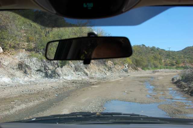
the hardest part of the drive is probably the first five miles or so. about a half mile into the cutoff drive you will find a detour to the right that leads you down into the arroyo. the road apparently was damaged in the fall storms. in the arroyo, you will actually drive for about a mile next to and through the stream bed. we found shallow water on the first trip but much deeper water on the return trip...still navigable via rental car. if you make it through the arroyo fine, then you will see the detour road turn back up to the main road along a very narrow single lane path. along the entire drive between barilles and ventana we were amazed how many animals were on the roads. we literally had to stop for wildlife several times.....way more than in years past. thus we were definitely glad we did the drive in the daylight. with so many animals around I am sure that if you get stuck in the water in the arroyo you could just hook up to a random cow for a quick tow. i have driven the cutoff about fifteen times and it is currently in good shape overall, just always a pain to get on the right road at first. you could drive it at night, just harder to see the path through the arroyo and i would assume even more animals on the road.
eric what are your travel dates? our trip was cut so short. we had to fly home after 2 days. at least i got one great day on the water. if the doctor allows i may try to make it back in one month.
-scott
|
|
|
Kraemer

Since 24 Apr 2006
1735 Posts
Sky Pilot
Unicorn Captain
|
| Mon Jan 14, 08 5:48 pm |
|
|
| Anyone know how hitch-hike friendly it is from the airport to the beach?
|
|
|
eric
Since 13 Jan 2006
1804 Posts
XTreme Poster
|
| Mon Jan 14, 08 6:31 pm |
|
|
Hey Scott,
Glad you are healing! We are down 3/22-3/29. Fly in and out of Cabo.
Eric
|
|
|
endoshred
Since 22 May 2006
232 Posts
HR
Stoked
|
| Mon Jan 14, 08 7:04 pm |
|
|
eric-- sounds like we and the kids will be down that week also. how is construction?
-s
|
|
|
eric
Since 13 Jan 2006
1804 Posts
XTreme Poster
|
| Mon Jan 14, 08 8:51 pm |
|
|
| should be done by end of Feb. Loosk great and right on budget.
|
|
|
blancoh2o
Since 15 Mar 2005
1153 Posts
Oregon
Phishy
|
| Tue Jan 15, 08 8:33 am |
|
|
Kraemer,
Hitch Hike from SJDC? I doubt you will find anyone going to LaVentana from the SJDC airport. Last time I was at that airport the local Slimeshare drivers didn't even know where LaVentana was.
The one thing you do have going in your favor is that the Kite Expo is going to be happening the same weekend you arrive. Perhaps that will increase the kiter traffic through SJDC.
You will want to have a back up plan.....Make a rent-a-car reservation just in case, you can always not take the car if you find a ride with someone else. That way you can secure a rental rate and budget accordingly.
Twinfin told me you were staying at Kirk's...Give Tom a call in CA and ask him if the shuttle is picking up anyone else at the same time as you and see if you can catch a ride with them. I believe the van is $350 each way.
Another option is to ride the bus......It does take a long time, but is a good experience. The bus stop is out on Mex 1. just follow the locals to the stop and grab the bus to LaPaz. The directions to LaVentana from LaPaz on the bus is on the Capt Kirk's website. It's not a bad ride and it is CHEAP.
|
|
|
purdyd
Since 27 Nov 2006
41 Posts
|
| Thu Jan 17, 08 9:55 pm |
|
|
| endoshred wrote: | we just drove the san antonio cutoff last week.
about a half mile into the cutoff drive you will find a detour to the right that leads you down into the arroyo. the road apparently was damaged in the fall storms. in the arroyo, you will actually drive for about a mile next to and through the stream bed. |
always an adventure
 |
| |
flash_175Baja_024DSC_6569.JPG |
|
|
|
|